Geotagging pictures allows you to more easily search your photos based on where you’ve been. In addition to online tools such as flickr and Picasa, desktop apps like iPhoto will take advantage of geotags. (Facebook is a notable exception; it currently doesn’t use geotags.)
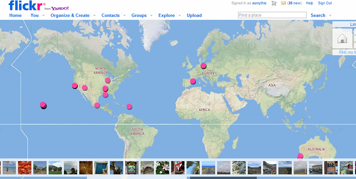
You can also create visualizations of your travels like this:

Digital photo files contain EXIF headers that store information about the picture. The information that most people are familiar with is the time and date. Each picture can contain hundreds of fields that include minutiae about the cameras settings, including aperture, shutter speed, program modes, etc. Geotags store latitude, longitude and elevation. You can see a sample of EXIF data on flickr. (The geotags are toward the bottom of the page.)
Unfortunately, the actual process of geotagging is still cumbersome. It’s a lot easier than it used to be, but shy of what it should be to make it mainstream.
Here are a few options for geotagging your pictures:
A dedicated GPS that can record GPX tracklogs
 A hiking GPS can record your every move. As you walk, hike or run, the GPS unit logs your current location. (As frequently as once per second.) These are recorded on a memory card in a .gpx file. When you return to your computer, you can pull that file and then the photos from your camera’s memory card. Specialized software (such as GeoSetter) then synchronizes the timestamps of the photos with the data from the GPX tracklog and writes the location information into the file.
Don’t worry if the timestamps are off. GeoSetter offers numerous ways to adjust the timestamps so that the time recorded in your pictures lines up with the time in the location data. (To make this easier, I recommend taking a picture of the time display on your GPS at the beginning and end of your trip.)
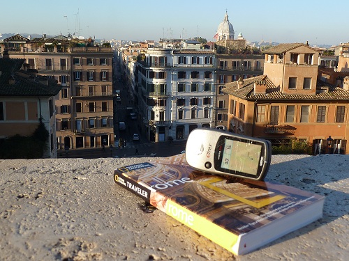
I’ve used a Garmin eTrex Vista Cx. Any GPS that can write GPX files to a memory card will do the trick.
Advantages: Works really well when outdoors. Precise location, due to GPS accuracy and frequency of updates. The GPS also provides valuable information when you are hiking.
Disadvantages: Additional cost for the GPS unit. Because you aren’t looking at the GPS unit when taking pictures, you may miss errors such as being out of coverage, dead batteries or a full memory card. It’s another thing to carry. Applying the coordinates is a multi-step process. If you go to a distant location, the GPS can take up to 20 minutes to get an initial fix. It may be difficult to get a fix in densely packed urban areas. (In any case, when you head indoors, you’ll have to rely on the last reading.)
Using an Android or iPhone app to record GPX tracklogs
This works pretty much the same as having a dedicated GPS, except that it relies on your cell phone to track your position. The biggest downside is that it will chew through your phone’s battery very quickly. I use Motion-X GPS on the iPhone and My Tracks on Android.
Advantages: Works really well whether indoors or outdoors. Precise location, due to GPS accuracy and frequency of updates. The GPS also provides valuable information when you are hiking. No additional cost. Because the phone can approximate your location in other ways, the time to a GPS fix is much faster.
Disadvantages: Because you aren’t looking at the phone when when taking pictures, you may miss errors such as being out of coverage, dead batteries or a full memory card. Multi-step process. The GPS app will chew through your phone’s battery very quickly.
A geotagging digital camera
Specialized digital cameras can automatically geotag photos. I have a Panasonic DMC-ZS7. It will automatically write the current location into the data file when you take a picture. No lining up separate files or manually geotagging pictures. The Panasonic has a built-in landmarks database. Standing in front of the Statue of Liberty? The screen will show “Statue of Liberty”. In playback mode, the camera will let you browse pictures by location.
Incredible? Yes. Too good to be true? Sadly, also yes. When it works, it’s like magic. When it doesn’t… it just adds incorrect data to the picture.
There are two big problems with Panasonic’s implementation: it takes way too long to get a fix and it doesn’t update when the camera takes a picture. Often when I’ve arrived in a new location, the camera is still showing the old location hours later. The instructions claim that the camera updates location even when it’s off; I haven’t found that to be true. Even at its best, the location only updates every five minutes. Undoubtedly, the camera’s designers faced challenges trading off the accuracy of the GPS location against battery life. The balance they struck made the GPS feature largely useless.
Advantages: Simplicity. Works OK when outdoors. Because the location is shown on screen, you can determine whether it’s correct and that there are no other issues.
Disadvantages: Location information is often wrong. Very long time to first fix. The GPS uses the camera’s battery. (I didn’t find this to be a huge issue, but you may want to carry a spare battery.) Despite the fact that the camera knows the nearby landmark, it doesn’t write it into the EXIF data in a way flickr and other tools can read. Poor indoor coverage. Additional cost when compared with cameras without GPS capability.
Eye-Fi memory card
Eye-Fi sells a line of memory cards that will geotag locations. The primary purpose of the cards is to automatically upload your pictures to the Internet. But they’ve expanded the capabilities to also geotag the pictures.
Here is how Eye-Fi works: when you take pictures, nearby WiFi networks are recorded. During the upload process, those network locations are used to compute a location using Skyhook’s database of WiFi locations.
Advantages: Simplicity. Works well indoors, especially dense urban areas in the United States.
Disadvantages: The Eye-Fi cards cost substantially more than comparable SD cards (sometimes 10x). It won’t work when you’re in an area without WiFi signals, which rules out EyeFi for geotagging many hikes. The Eye-Fi card’s WiFi capabilities will drain your camera’s battery faster. The locations are added after the fact, so you won’t be aware of any problems when shooting. Geotagging relies on Skyhook’s database of WiFi locations, which can be sparse in foreign locations.
Manually geotagging pictures
For a while, this was the only option. Take pictures that you’ve uploaded and drag them onto a map. This can be as accurate or as inaccurate as you want it to be.
You can take all of your pictures of Venice and drop them onto the city of Venice. Or you can zoom in to just the right piazza and repeat the process for each picture. I once looked into the background of an old picture, found a business name there and did a Google Maps search to put it in the right place. It can be tedious, fun or both. Flickr and Picasa both support manual geotagging.
Advantages: Doesn’t cost anything other than your time. You have precise control over where each picture is placed.
Disadvantages: It can be extremely tedious. Lining up pictures taken outdoors (such as while skiing or hiking) can be difficult.
Using your cellphone’s camera
This is likely the way that most people get into geotagging. If you have an Android phone or iPhone, your camera can do all of the work for you. Based on the same services used for maps and other location services, the phone will write the picture’s coordinates straight into the file. You can also verify that the location is correct by launching a maps app before taking the picture.
It’s so easy that many privacy advocates worry that people are unintentionally revealing their locations when uploading pictures.
Advantages: Simplicity. Can verify information on screen. No additional cost.
Disadvantages: As good as they are, the cameras on phones aren’t as good as regular cameras. This is especially true for pictures needing zoom or taken in low light.
The best solution would be if the camera manufacturers would work with the phone manufacturers to just read the current GPS data when the shutter is pressed. I’d bet that the iPhone gets a microSD card slot before that happens.

How will Color handle elevation as a vector in determining groups?…
Although you can get elevation from GPS, if you are in a building, chances are you aren’t getting a GPS signal at all. The first cut at location likely comes from WiFi positioning. This is how the iPod Touch and non-3G iPads determine location. For mo…
[…] EXIF marks the spot: a guide to geotagging pictures […]
[…] I've seen GPS as accurate as 8 or 9 ft. Indoors, location accuracy will vary dramatically. See https://redesignmobile.com/2011/0… for a discussion of different ways of doing geolocation.Rakesh Agrawal • 7:53pmView All 2 […]